


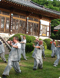
SPECIAL INTEREST
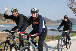
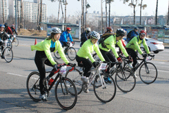
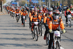
Korea by Bike 19 days
Tour Highlights
- Gyeongbokgung Palace
- National Folk Museum of Korea
- Insadong
- Namdaemun Market
- Peace Dam
- The 4th Tunnel
- Eulji Observatory
- Misan Valley
- Unduryeong Pass
- Hwangji Pond
- Dosanseowon Confucian Academy
- Hahoemaeul Village
- Speed train
Note
Please read the following carefully.
All distances, times, and road conditions mentioned in this program are estimates and provided for guidance only.
Your safety and well-being are your personal responsibility.
Ride responsibly:
Maintain a safe speed, yield the right-of-way, and never ride under the influence of alcohol.
Daytime riding only: Rides are scheduled strictly between sunrise and sunset.
Weather conditions:
Rides will be canceled during bad weather, including:
Extreme heat or cold
Strong winds
Heavy rain or fog
Equipment & Gear:
We provide bicycles and a basic tool set.
You must bring:
A helmet (mandatory)
High-visibility or reflective clothing for low-light or cloudy conditions
Road & Riding Etiquette
Obey all traffic laws ? cyclists must follow the same rules as motorists.
Always use correct hand signals before turning.
Ride in single file, in the same direction as traffic.
Practice courtesy and awareness when sharing the road.
Be Alert for Hazards
Stay aware of your surroundings at all times.
Watch out for:
Opening car doors
Potholes
Sewer grates and road debris
Uneven pavement
Poorly lit tunnels or underpasses
By participating, you agree to follow these guidelines and exercise caution throughout the ride.
Tour from April through October |
| Tour facts and features | |
| Accommodation | 18 hotel and pension nights in 2 and 4 star twin share accommodation |
| Meals | 7 breakfasts |
| Transport | All transportation by private vehicle, and speed train |
| Guided | Services of an English speaking guide |
| Group size | Maximum 6 |
| Age range | 18+ |
| Activity | Cycling of 12 days |
| Degrees of difficulty | Very difficult |
Note
Any figures like distance, times or road conditions stated in the bicycling program are estimate and just for guideline purpose
You need to understand you are responsible for your safety and health
Riding at proper speed, yielding right-of-way, not riding while under the influence of alcohol
The ride is strictly during the day, not before sunrise or after sunset
The riding will not be arranged on bad weather conditions such as extremely hot, cold, windy, foggy or rainy days. In such case, supporting vehicle cares the transportation of your bicycles
We provide bicycles and a set of fixing tool for the group
You are required to bring your helmet, highly visible or reflective clothing for low-visibility conditions
Cyclists need to follow the same rules as motorists
Always use correct hand signals before turning
Ride in single file with traffic, not against it
Bikeways are well established in areas, but much of roads are sharing with pedestrians, bicyclists and motorists. You need to understand how to safely and courteously share the road
Bicyclists need to be aware of their surroundings. Watch for opening car doors, sewer grating, debris on the roads, uneven surfaces, and poorly lit tunnels
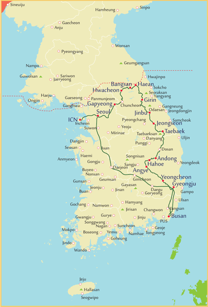
Click on the days to access the programs quick
| Days | Visits and Activities | Distance |
| Day 1 | Arrive Seoul | 60km |
| Day 2 | Seoul | |
| Day 3 | Seoul - Paldang - Cheongpyeong - Gapyeong | 72km |
| Day 4 | Gapyeong - Chuncheon - Hwacheon | 60km |
| Day 5 | Hwacheon - Peace Dam - Bangsan | 52km |
| Day 6 | Bangsan - Dolsanryeong - Haean | 38km |
| Day 7 | Haean | |
| Day 8 | Haean - Wontong - Girin | 72km |
| Day 9 | Girn - Unduryeong - Soksa - Jinbu | 86km |
| Day 10 | Jinbu - Mungok - Jeongseon - Hwaam | 60km |
| Day 11 | Hwaam - Samsuryeong - Taebaek | 45km |
| Day 12 | Taebaek - Dosan - Andong | 123km |
| Day 13 | Andong | |
| Day 14 | Andong - Hahoe - Yonggi | 76km |
| Day 15 | Yonggi - Yeongcheon | 80km |
| Day 16 | Yeongcheon - Gyeongju | 48km |
| Day 17 | Gyeongju - Eonyang - Yangsan - Busan | 120km |
| Day 18 | Busan - Seoul | 450km |
| Day 19 | Departure | 60km |
 Day 1 Arrive Seoul (- - -)
60km
Touching down at Incheon International Airport places you in the heart of Korea. After you clear Passport and Customs control, you will be welcomed by the tour guide and then transferred to your hotel.
Day 2 Seoul (B)
Your exploration this morning begins with a driving tour of Seoul, featuring sites such as Seoul Plaza, City Hall, Cheonggye Square and pedestrian-friendly Gwanghwamun Plaza that is hemmed in on both sides by rushing traffic and office buildings.
Step back in time to when life was gracefully slow and discover Gyeongbokgung Palace, a particularly charming spot that represents a colorful and turbulent side of the capital's 500-year history. Depending on timing, you may witness the Royal Guard Changing Ceremony featuring parade, password verification, duty shift and patrolling the gate. Accompanied by a court band with its colorful costumes and royal flags, the ceremony is performed daily basis at 10:00 and 14:00 except Tuesdays, although it is cancelled in case of rain or extremely hot or cold weather.
Your visit to the National Folk Museum of Korea will familiarize you with wealthy culture of this friendly and picturesque nation. It is an excellent facility to illustrate the history of traditional life of the Korean people from the prehistoric age to the Joseon dynasty. The permanent exhibition features life and work, costumes and ornaments, handicrafts and technology, educations, living quarters, dietary life, oriental medicine, performing arts and games, beliefs and rituals, and
socio cultural life.
Insadong, at one time the center of traditional Korean art and antiques, features a mixture of historical and modern atmosphere representing the cultural glimpse of the nation. Clustered along the main street and alleys are lined with street vendors, wooden tea houses, restaurants and numerous galleries and shops dealing in antiques, oriental art supplies, and modern Korean art of all types and styles. Soak in the paintings, upscale artworks, antiques and potteries while you can. Get lucky and you just might meet the artist themselves. It can be plenty of fun walking on the main street, but you venture into the hidden alleys that do spring some unexpected surprises. While here, you may want to buy some souvenirs or simply wander and browse at leisure admiring cultural ambience.
You will tour the centuries-old Namdaemun Market brimming with well over 11,000 shops selling anything you can imagine. One of the most colorful aspects of the market is an endless sprawl of street-vendor stalls that setup in the alleys and walkways between the buildings. The market is seriously crowded, so be prepared to get bumped around. A fantastic place to haggle over the price to get the best deal on something you want or simply admire the vibrancy of this massive market.
At the western entrance of the market in the middle of a traffic circle stands Sungnyemun. It is a formidable and iconic construct that served as the southern gate of the wall that surrounded Seoul during the period of the Joseon Dynasty.
Day 3 Seoul - Paldang - Cheongpyeong - Gapyeong (B) 72km
Upon arrival at Gwangnaru Bicycle Park, pick up your bike and allow time for a proper fitting. This includes adjusting pedals and cleats, cycling shoes, crank arm length, saddle selection, saddle height, fore?aft position and tilt, as well as handlebars and brake levers.
A proper bike fit is essential to help you produce maximum power as efficiently as possible. It ensures a comfortable riding position that allows you to ride for as long as you want while staying comfortable throughout the journey.
The route is a combination of dedicated bikeways and car roads. The day’s tour can be roughly divided into three sections
Gwangnaru Bicycle Park to Ungilsan Station (27 km)
Ungilsan Station to Sincheongpyeong Daegyo Bridge (23 km)
Sincheongpyeong Daegyo Bridge to Gapyeong (22 km)
The ride begins at Gwangnaru Bicycle Park and follows a traffic-free bikeway up to Paldang Bridge. After crossing the bridge, the route continues along an old railway line toward Ungilsan Station, followed by scenic bike paths and car roads leading to Gapyeong. Nestled among mountains, rivers, and lakes, Gapyeong is a beautiful town and one of the region’s most popular destinations for relaxation and vacations.
Day 4 Gapyeong - Chuncheon - Hwacheon (B) 60km
This is a physically demanding, long-distance tour that covers much of the country’s length. Riders will encounter limited flat sections, rolling terrain, and multiple high mountain passes, with daily routes winding through scenic valleys. Due to the sustained climbs and long distances, this tour is recommended only for highly experienced cyclists with strong endurance and confident bike-handling skills. The first section toward Chuncheon follows a dedicated bikeway that is relatively flat and enjoyable, allowing riders to warm up before the more challenging terrain ahead. Along the way, you will cycle through impressive natural landscapes, pass charming rural villages, and share the road with local residents.
From the Sindong Samgeori fork in Chuncheon, the route introduces its first major climb. This steady uphill section requires sustained effort and is followed by a long, enjoyable descent. Afterward, the terrain eases into a flatter stretch leading toward Hwacheon. On Road 403, riders will approach the Budari Tunnel (2,067 m). Cycling through the tunnel is avoided by using an alternative route: on the left side near the tunnel entrance, there is a paved old road that has been barricaded to block vehicle traffic. Follow this quiet road for approximately 2.5 km, then turn right toward Samhwari village (삼화리) and continue on to Hwacheon.
Day 5 Hwacheon - Peace Dam - Bangsan (- - -) 52km
The day’s route is defined by long, sustained climbs followed by extended descents, with repeated transitions through river valleys. After approximately 16km of riding through a gentle river valley, the route reaches Pungsan 2-ri (풍산2리). From there, the journey continues over Hanmukryong Pass, followed by a long descent to Angong Steel Bridge.
About 6 km further on, you will arrive at the Peace Dam, a massive structure standing 125 m high and 601 m wide. Completed in 2005, the dam was built as a preventive measure against potential catastrophic flooding in the event of a collapse?accidental or intentional?of the upstream Imnam Dam in North Korea. Notably, the Peace Dam does not hold water and functions solely as a flood-control structure.
Take time to visit the World Peace Bell, a powerful symbol made from spent cartridge cases collected from conflict zones around the world. The bell weighs 37.5 tons but remains intentionally incomplete. Nearby, you will see a broken pigeon wing on display; it will be added to complete the bell on the day of Korean reunification.
After a short downhill section and valley ride, the route presents another demanding uphill climb. Several tunnels follow along the way, including Pyeonghwa Tunnel (173 m), Yanghwa Tunnel (329 m), Ocheon Tunnel (1,280m), and Dogo Tunnel, before reaching Bangsan. This section features long, uninterrupted stretches of road with few intersections or stop signs, creating a sense of remoteness compared to the river valleys. The surrounding scenery is striking, and even on weekdays, the route offers a strong sense of quiet and isolation?making it both mentally and physically demanding, yet highly rewarding.
Day 6 Bangsan - Dolsanryeong - Haean (- - -) 38km
The mountains along this section are endless and still towering, offering continuous climbing and descending through villages such as Omi, Geumak, Jangpyeong, and Gobangsan. Shortly after passing through the Dogo Tunnel (639 m), turn left to join Road 31 heading toward Haean.
The route then follows a gentle valley that winds past small villages like Deokgok, Imdang, and Wolwun. At the last fork before Wolwun Reservoir, take Road 453 and continue toward Haean. Ahead lies another major challenge: Dosolsan Mountain, part of which?Dolsanryeong Pass? providing a never-ending climb that will test even experienced cyclists.
After conquering the pass, riders are rewarded with the breathtaking Punch Bowl, a natural geologic bowl several kilometers wide, ringed on all sides by steep mountains. The fertile land within the bowl has made it one of the richest farming areas in the region, and the surrounding scenery is strikingly beautiful.
However, the area also carries deep historical significance. During the Korean War, the Punch Bowl was a key strategic location and the site of several fierce battles. The Battle of Bloody Ridge took place here from August to September 1951, followed immediately by the Battle of Heartbreak Ridge from September to October 1951. Meanwhile, the 1st Marine Division, reinforced by the Korean Marine Corps Regiment, captured the surrounding hills during the Battle of the Punch Bowl from 31 August to 20 September 1951.
Day 7 Haean (B)
The day at your relaxation.
If you wish, you can join an optional tour covering the 4th Tunnel, secretly dug by North Korea, and Eulji Observatory. Please note that this tour does not operate on Mondays.
The 4th Tunnel was discovered on March 3, 1990. It was dug through solid granite to a depth of 145 meters underground and stretches 2.1 km southward, crossing the Military Demarcation Line (MDL). Unlike the other three tunnels, visitors here take a short monorail ride inside the tunnel, providing a unique and safe way to explore this historic site.
Eulji Observatory is located on one of the bitterest battlegrounds of the Korean War. Perched at 1,049 m above sea level, near the MDL, it now serves as an informative historical site. From the observation platform, you can view North Korean soldiers on guard, offering a vivid perspective on the region’s tense history.
This optional tour provides a fascinating blend of history, geopolitics, and breathtaking views, perfect for those interested in understanding the Korean Conflict while enjoying spectacular scenery.
Day 8 Haean - Wontong - Girin (- - -) 72km
The itinerary will take you through small villages full of tradition, where you can experience the special charm of the local communities. The route includes approximately 33 km of gently winding valley roads,
with a few rolling hills, leading to Wontong. Once in Wontong, the terrain becomes mostly flat, and the road opens into a two-lane road with traffic in both directions, making for a comfortable and enjoyable ride.
Day 9 Girn - Misan Valley - Unduryeong - Soksa - Jinbu (B) 86km
Today is one of the most challenging rides of the tour, but the experience is rewarded by the stunning autumn scenery, with vibrant colors and strong contrasts creating a cozy and breathtaking landscape.The route winds through steep mountains and narrow roads along streams, encouraging you to pedal harder?the more effort you put in, the more spectacular the views become. The ride includes a steep climb over Omijae Pass, followed by a pleasant downhill through scenic, gentle valleys. The challenge continues with a climb over Unduryeong Pass (1,089 m), leading to Soksa Samgeori fork. Turn left and continue toward Jinbu via a combination of Soksajaegil and Gyeonggang-ro.
The surrounding landscape features a chain of high mountains, while the valleys are sparsely dotted with small, peaceful retired villages, offering both challenge and serenity along the way.
Day 10 Jinbu - Mungok - Jeongseon - Hwaam (- - -) 60km
Gentle Valleys with Tunnel Challenges. The mountains remain high, and the roads wind along scenic river valleys. Overall, the elevation is low, and the terrain features a gentle downhill toward Jeongseon, making this section relatively easier on the legs. However, riders should be prepared for three tunnels along the way, which require extra caution and proper lighting.
Day 11 Hwaam - Taebaek (- - -) 45km
Traditional Towns & Scenic Valleys
Although the route may seem difficult to navigate, it is quite manageable once you start cycling. This ride offers a true connection with nature, allowing you to immerse yourself in the scenic mountains and winding valleys.
Along the way, you will have the opportunity to share unique moments with local residents and learn about their traditional lifestyle. This section is a delight for all the senses, passing through towns full of charm and authenticity.
The day is physically challenging, with endless mountains and winding valleys, but there are rewarding stops: There is a Wind Hill (Baram-ui Eondeok):
Perched on a high ridge near Taebaek, Wind Hill is famous for its strong, consistent winds and panoramic mountain views. The hill is dotted with wind turbines, creating a striking landscape that is both picturesque and inspiring for cyclists. The area is perfect for photography, short breaks, and simply enjoying the fresh mountain air.
Day 12 Taebaek -
Andong (B) 123km
The day starts with winding uphill roads that test your endurance. The first section in Taebaek follows a crowded, fast-moving two-lane road, so extra caution is needed. After this, the route continues along a steep mountain path, offering beautiful natural scenery, though the road is narrow and partially under construction, making careful riding essential.
At Yuksongjeong Samgeori, turn right to begin the endless, winding climb of Neutjae Hill (896 m), stretching approximately 11km. After conquering this climb, enjoy a short steep descent leading to Taebaek-ro.
Following a short rejoin, the bike path continues toward Goseon-ri villages and Hyeondong Samgeori fork. The navigation here can be a bit tricky: make a left turn at Hyeondong Samgeori and follow the route through the town to Hyeondong Tunnelfor about 1km. Just before the tunnel, take a right fork onto the local road (Imgiro) that runs along a winding stream, offering a more peaceful ride.
From this point onward, the cycling difficulty moderates, with gently rolling terrain all the way to Dosanseowon Confucian Academy, a historic site dating back to the 16th century. After a short visit, continue on toward Andong.
Day 13 Andong (B)
The day is at leisure, however you may want to tour Andong.
Enjoy the local ambience exploring the Andong Jungangsijang market selling a wide array of merchandises, vegetables, fishes and fruits. At the one end of the market is an alley specializing in braised chicken. It’s savory, mildly salty and sweet with a very subtle spicy kick. Perhaps you may want to try it. The neighboring blocks are filled with fancy stores, cafes and restaurants. The atmosphere are very welcoming. There is a Confucian Land that offers a chance to experience the culture of Confucianism. Overall 15km riding covers them all.
Day 14 Andong - Hahoe - Yonggi (- - -) 76km
This biking tour takes you to Hahoe Village (Hahoemaul), a UNESCO World Heritage Site dating back to the 15th century. Hahoe is one of Korea’s best-preserved traditional villages, providing a unique window into life during the Joseon Dynasty (1392-1910). The village still has approximately 480 traditional Korean houses, both large and small, many of which remain fully functional today. As you ride through the village, take time to stroll along the narrow alleys and enjoy the rustic and historic charm. After exploring Hahoe, continue your ride toward Yonggi. From Yonggok Samgeori fork, take Road 923, a scenic and lightly trafficked route, offering a pleasant and relaxing cycling experience through peaceful countryside landscapes.
Day 15 Yonggi - Yeongcheon (- - -) 80km
Today’s ride passes through a number of small traditional villages, giving you a glimpse of rural life along the way. There are several route options, allowing some flexibility depending on your pace and interests. Along the route, you will encounter bridges, forks, crossroads, and some defunct railroad crossings, which require attention while riding. The roads are mostly gentle and flat, making for a relatively easy ride. However, as you approach Yeongcheon, traffic increases on certain stretches, so exercise extra caution in busier areas.
Day 16 Yeongcheon - Gyeongju (B) 48km
With a new highway built along this section, your ride follows the old road, which winds gently through thesmall towns and villages. While the route may feel a little narrow and winding, it offers significantly less traffic, making it a safer and more enjoyable cycling experience. Upon arrival Gyeongju, you will have plenty of time to relax, or you can explore the city on your bike at your own pace. Today’s itinerary also includes a visit to one of the world’s ten most historically significant sites, featuring:
ancient temples, Weathered stone pagodas,
Royal tombs,
Buddhist bas-reliefs, and
Fortress ruins.
This combination of cycling and cultural exploration makes for a memorable and enriching day, blending light exercise with the opportunity to experience Korea’s rich heritage.
Day 17 Gyeongju - Eonyang - Yangsan - Busan (B) 120km
Challenging Final Leg - Navigating to the Southern tip of Korea
Today’s bike path can be tricky to navigate, as many old roads have been converted into highways. you will need to ride farm roads, back roads, and occasionally share sections with four-lane highways in both directions.
Despite the challenges, the route gradually leads to a scenic riverside bikeway, taking you all the way to the southern tip of Korea, offering a rewarding finish to your journey.
Day 18 Busan - Seoul (B) 450km
After a hearty breakfast and with leisurely time to pack,travel back to Seoul on a high speed train.
Day 19 Departure (B) 60km
After this wonderful trip exploring Korea and with time to reflect on your surprise in your experience, Then transfer to the airport in time for your flight. By boarding, you are already high above Incheon heading for home.
